|
Unofficial Property Record Card - Falmouth, MA
|
|

|
|
General Property Data
|
|
|
| Parcel
ID |
02 01 015C 002A |
Account
Number |
NORTH FALMOUTH |
| Prior Parcel
ID |
-- |
| Property
Owner |
BRYANT POINT LLC |
Property
Location |
47 BRYANT POINT RD |
| |
|
Property
Use |
ONE FAMILY |
| Mailing
Address |
7936 GRAND BAY DRIVE #27 |
Most
Recent
Sale Date |
9/16/2013 |
| |
C/O FRANCIS K DUANE |
Legal
Reference |
27693-50 |
| City |
NAPLES |
Grantor |
KETCHEN TRUSTEE,SUSAN N |
| Mailing
State |
|
Sale Price |
1,100,000 |
| ParcelZoning |
RB |
Land Area |
0.544 acres |
|
|
|
|
|
Current Property Assessment
|
|
|
| Card 1 Value |
Building Value |
1,064,800 |
Xtra Features Value |
0 |
Land Value |
1,851,900 |
Total Value |
2,916,700 |
|
Total Parcel Value |
Building Value |
1,064,800 |
Xtra Features Value |
0 |
Land Value |
1,851,900 |
Total Value |
2,916,700 |
|
|
|
|
|
| Legal Description
|
|
|
|
|
|
|
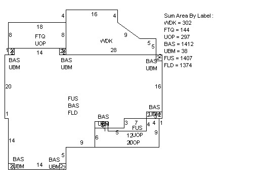
| Narrative Description of Property
|
|
|
|
This property contains 0.544 acres of land mainly classified as
ONE FAMILY
with a(n) Gambrel style building, built about
2014 , having Wood Shingle exterior and Asphalt
roof cover, with 1
unit(s), 8
room(s), 4
bedroom(s), 3
bath(s), 1 half bath(s). |
|