|
Unofficial Property Record Card - Falmouth, MA
|
|

|
|
General Property Data
|
|
|
| Parcel
ID |
02 01 015F 005 |
Account
Number |
NORTH FALMOUTH |
| Prior Parcel
ID |
-- |
| Property
Owner |
OSULLIVAN TRUSTEE JOAN G |
Property
Location |
55 BRYANT POINT RD |
| |
OSULLIVAN FAMILY TRUST |
Property
Use |
ONE FAMILY |
| Mailing
Address |
97 ANDERER LN |
Most
Recent
Sale Date |
5/9/1975 |
| |
APT 307 |
Legal
Reference |
02181-27 |
| City |
WEST ROXBURY |
Grantor |
|
| Mailing
State |
|
Sale Price |
0 |
| ParcelZoning |
RB |
Land Area |
0.253 acres |
|
|
|
|
|
Current Property Assessment
|
|
|
| Card 1 Value |
Building Value |
159,500 |
Xtra Features Value |
0 |
Land Value |
701,500 |
Total Value |
861,000 |
|
Total Parcel Value |
Building Value |
159,500 |
Xtra Features Value |
0 |
Land Value |
701,500 |
Total Value |
861,000 |
|
|
|
|
|
|
Building Description
|
|
|
| Building
Style |
Ranch |
Foundation
Type |
|
Flooring
Type |
Carpet |
| # of Living
Units |
1 |
Frame
Type |
|
Basement
Floor |
N/A |
| Year
Built |
1957 |
Roof
Structure |
Gable/Hip |
Heating
Type |
Frcd Hot Air |
| Building
Grade |
5 1.20 |
Roof
Cover |
Asphalt |
Heating
Fuel |
Gas |
| Building
Condition |
Average |
Siding |
Wood Shingle |
Air
Conditioning |
100% |
| Finished
Area (SF) |
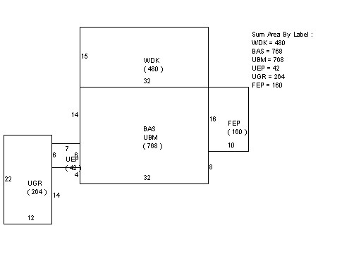
768 |
Interior
Walls |
Drywall |
# of Bsmt
Garages |
0 |
| Number
Rooms |
4 |
# of
Bedrooms |
2 |
# of Full
Baths |
1 |
| # of 3/4
Baths |
0 |
# of 1/2
Baths |
0 |
# of Other
Fixtures |
0 |
|
|
|
|
| Legal Description
|
|
|
|
|
|
|
| Narrative Description of Property
|
|
|
|
This property contains 0.253 acres of land mainly classified as
ONE FAMILY
with a(n) Ranch style building, built about
1957 , having Wood Shingle exterior and Asphalt
roof cover, with 1
unit(s), 4
room(s), 2
bedroom(s), 1
bath(s), 0 half bath(s). |
|
|
|
| Property Images
|
|
|