|
Unofficial Property Record Card - Falmouth, MA
|
|

|
|
General Property Data
|
|
|
| Parcel
ID |
24 07 001A 035A |
Account
Number |
WEST FALMOUTH |
| Prior Parcel
ID |
-- |
| Property
Owner |
SHOLLEY TRUSTEE J ADAM |
Property
Location |
198 ASSOCIATES RD |
| |
RABIDOUX TRUSTEE LUCINDA SHOLLEY |
Property
Use |
ONE FAMILY |
| Mailing
Address |
77 MORTON RD |
Most
Recent
Sale Date |
1/11/1994 |
| |
|
Legal
Reference |
08996-0333 |
| City |
MILTON |
Grantor |
SHOLLEY NANCY F |
| Mailing
State |
|
Sale Price |
0 |
| ParcelZoning |
RB |
Land Area |
2.308 acres |
|
|
|
|
|
Current Property Assessment
|
|
|
| Card 1 Value |
Building Value |
547,000 |
Xtra Features Value |
3,500 |
Land Value |
2,524,700 |
Total Value |
3,075,200 |
|
Total Parcel Value |
Building Value |
547,000 |
Xtra Features Value |
3,500 |
Land Value |
2,524,700 |
Total Value |
3,075,200 |
|
|
|
|
|
| Legal Description
|
|
|
|
|
|
|
| Narrative Description of Property
|
|
|
|
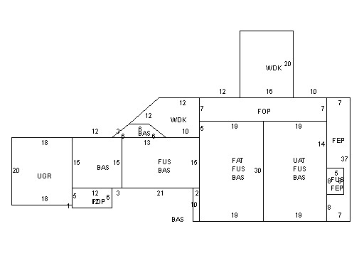
This property contains 2.308 acres of land mainly classified as
ONE FAMILY
with a(n) Colonial style building, built about
1894 , having Wood Shingle exterior and Asphalt
roof cover, with 1
unit(s), 8
room(s), 5
bedroom(s), 4
bath(s), 0 half bath(s). |
|