|
Unofficial Property Record Card - Falmouth, MA
|
|

|
|
General Property Data
|
|
|
| Parcel
ID |
24 16 012 000 |
Account
Number |
WEST FALMOUTH |
| Prior Parcel
ID |
-- |
| Property
Owner |
OLMSTED GORDON M |
Property
Location |
593 WEST FALMOUTH HWY |
| |
OLMSTED DEBORAH A |
Property
Use |
OFFICE |
| Mailing
Address |
90 DEER POND RD |
Most
Recent
Sale Date |
4/15/1994 |
| |
|
Legal
Reference |
09149-0240 |
| City |
EAST FALMOUTH |
Grantor |
LANDERS NANCY H |
| Mailing
State |
|
Sale Price |
136,000 |
| ParcelZoning |
B3 |
Land Area |
0.340 acres |
|
|
|
|
|
Current Property Assessment
|
|
|
| Card 1 Value |
Building Value |
110,200 |
Xtra Features Value |
0 |
Land Value |
308,100 |
Total Value |
418,300 |
|
Total Parcel Value |
Building Value |
110,200 |
Xtra Features Value |
0 |
Land Value |
308,100 |
Total Value |
418,300 |
|
|
|
|
|
|
Building Description
|
|
|
| Building
Style |
Office Build |
Foundation
Type |
|
Flooring
Type |
Softwood |
| # of Living
Units |
1 |
Frame
Type |
Wood |
Basement
Floor |
N/A |
| Year
Built |
1850 |
Roof
Structure |
Gable/Hip |
Heating
Type |
Hot Water |
| Building
Grade |
5 1.20 |
Roof
Cover |
Asphalt |
Heating
Fuel |
Oil |
| Building
Condition |
Average |
Siding |
Wood Shingle |
Air
Conditioning |
0% |
| Finished
Area (SF) |
1104 |
Interior
Walls |
Plaster |
# of Bsmt
Garages |
0 |
| Number
Rooms |
0 |
# of
Bedrooms |
0 |
# of Full
Baths |
0 |
| # of 3/4
Baths |
0 |
# of 1/2
Baths |
1 |
# of Other
Fixtures |
0 |
|
|
|
|
| Legal Description
|
|
|
|
|
|
|
| Narrative Description of Property
|
|
|
|
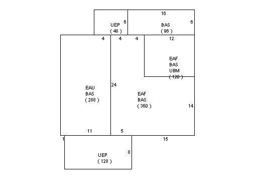
This property contains 0.340 acres of land mainly classified as
OFFICE
with a(n) Office Build style building, built about
1850 , having Wood Shingle exterior and Asphalt
roof cover, with 1
unit(s), 0
room(s), 0
bedroom(s), 0
bath(s), 1 half bath(s). |
|
|
|
| Property Images
|
|
|