|
Unofficial Property Record Card - Falmouth, MA
|
|

|
|
General Property Data
|
|
|
| Parcel
ID |
25 04 020 000 |
Account
Number |
WEST FALMOUTH |
| Prior Parcel
ID |
-- |
| Property
Owner |
PLATT WALTER H B |
Property
Location |
26 DRIFT RD |
| |
SUTHERLAND PLATT JULIE |
Property
Use |
ONE FAMILY |
| Mailing
Address |
2 OLD AYER RD |
Most
Recent
Sale Date |
12/7/2012 |
| |
|
Legal
Reference |
26924-184 |
| City |
GROTON |
Grantor |
PLATT,WALTER H B |
| Mailing
State |
|
Sale Price |
100 |
| ParcelZoning |
RB |
Land Area |
2.930 acres |
|
|
|
|
|
Current Property Assessment
|
|
|
| Card 1 Value |
Building Value |
146,500 |
Xtra Features Value |
5,700 |
Land Value |
1,847,800 |
Total Value |
2,000,000 |
|
Total Parcel Value |
Building Value |
146,500 |
Xtra Features Value |
5,700 |
Land Value |
1,847,800 |
Total Value |
2,000,000 |
|
|
|
|
|
| Legal Description
|
|
|
|
|
|
|
| Narrative Description of Property
|
|
|
|
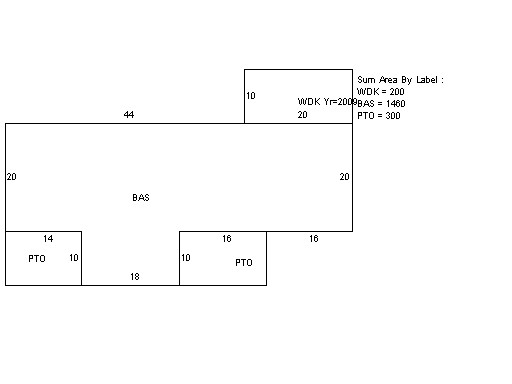
This property contains 2.930 acres of land mainly classified as
ONE FAMILY
with a(n) Cottage style building, built about
1920 , having Wood Shingle exterior and Asphalt
roof cover, with 1
unit(s), 8
room(s), 5
bedroom(s), 2
bath(s), 0 half bath(s). |
|