|
Unofficial Property Record Card - Falmouth, MA
|
|

|
|
General Property Data
|
|
|
| Parcel
ID |
27 05 004 011 |
Account
Number |
PINECREST |
| Prior Parcel
ID |
-- |
| Property
Owner |
ANASTASIA DEBORAH |
Property
Location |
67 CLEARWATER DR |
| |
|
Property
Use |
ONE FAMILY |
| Mailing
Address |
67 CLEARWATER DR |
Most
Recent
Sale Date |
12/30/2004 |
| |
|
Legal
Reference |
19397-281 |
| City |
EAST FALMOUTH |
Grantor |
HODGSON III,JOHN G |
| Mailing
State |
|
Sale Price |
1 |
| ParcelZoning |
RC |
Land Area |
0.350 acres |
|
|
|
|
|
Current Property Assessment
|
|
|
| Card 1 Value |
Building Value |
375,500 |
Xtra Features Value |
0 |
Land Value |
141,000 |
Total Value |
516,500 |
|
Total Parcel Value |
Building Value |
375,500 |
Xtra Features Value |
0 |
Land Value |
141,000 |
Total Value |
516,500 |
|
|
|
|
|
|
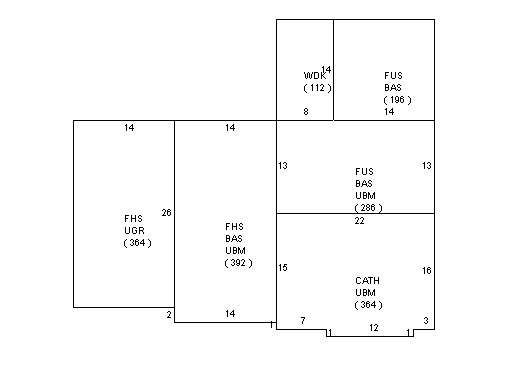
Building Description
|
|
|
| Building
Style |
Cape Cod |
Foundation
Type |
|
Flooring
Type |
Hardwood |
| # of Living
Units |
1 |
Frame
Type |
|
Basement
Floor |
N/A |
| Year
Built |
1994 |
Roof
Structure |
Gable/Hip |
Heating
Type |
Hot Water |
| Building
Grade |
5 1.20 |
Roof
Cover |
Asphalt |
Heating
Fuel |
Gas |
| Building
Condition |
Average |
Siding |
Clapboard |
Air
Conditioning |
0% |
| Finished
Area (SF) |
2287 |
Interior
Walls |
Drywall |
# of Bsmt
Garages |
0 |
| Number
Rooms |
6 |
# of
Bedrooms |
3 |
# of Full
Baths |
2 |
| # of 3/4
Baths |
0 |
# of 1/2
Baths |
1 |
# of Other
Fixtures |
0 |
|
|
|
|
| Legal Description
|
|
|
|
|
|
|
| Narrative Description of Property
|
|
|
|
This property contains 0.350 acres of land mainly classified as
ONE FAMILY
with a(n) Cape Cod style building, built about
1994 , having Clapboard exterior and Asphalt
roof cover, with 1
unit(s), 6
room(s), 3
bedroom(s), 2
bath(s), 1 half bath(s). |
|
|
|
| Property Images
|
|
|